A Complete Guide to Mullayanagiri Peak by Car (2026 Edition): Driving to the Clouds
The Highest Point in Karnataka is Calling
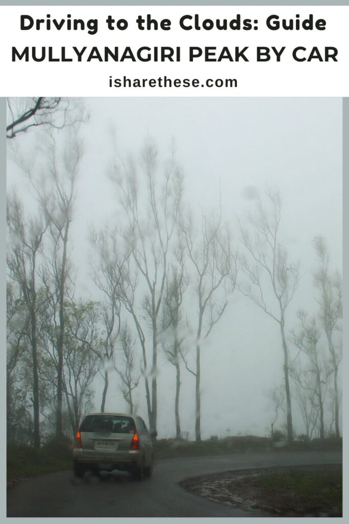
Driving up to Mullayanagiri Peak by car feels like entering another world. The mist rolls across the road without warning, cutting visibility down to just a few meters. Every hairpin bend demands complete attention. At 1,930 meters above sea level, this is Karnataka’s highest peak, and reaching it by car is an achievement in itself.
We (Arunabha, me and kids) drove our 2000 model Automatic Honda City to the summit. The experience taught me exactly what these mountain roads demand from both driver and vehicle. The route climbs steeply through narrow passages with sharp turns on one side and steep drops on the other. Mist-covered asphalt gives way to occasional gravel patches that test your grip and nerves.
– By Indrani Ghose | Last Updated: January 2026
But here’s what makes it worthwhile: the sense of accomplishment when you park at the top, step out into the clouds, and realize you’ve conquered Karnataka’s highest motorable point. Reaching Mullayanagiri Peak by car isn’t just about the destination—it’s about mastering a challenging drive through some of the Western Ghats’ most dramatic terrain.
If you’re planning this drive, know that preparation matters more than experience. The right vehicle condition, understanding of hill driving basics, and patience with the road will get you to the top safely.
Later we visited temples like: Lakshmi Narasimha temple in Javagal, Yoga Narasimha Temple in Baggavalli.

Mullayanagiri peak Chikamagalur Karnataka
Is it Safe to Drive up Mullayanagiri Peak by Car?
Safety concerns are valid when considering Mullayanagiri Peak by car. The road climbs steeply through hairpin bends, narrow passages, and sections where two vehicles barely pass each other. But after driving through, I can confirm: it’s safe if you prepare properly.
Vehicle condition matters most. Ground clearance becomes important on stretches with uneven surfaces and scattered gravel. Our Hona City scraped twice on particularly rough patches near the 5 km mark. SUVs and hatchbacks with 165mm+ clearance handle these sections better. Engine power affects your climb too—smaller engines strain on steep grades, especially with passengers and luggage. Our automatic transmission heating up on longer climbs, was something to monitor.
Driver readiness equals road safety. Mountain driving requires different skills than highway cruising. You need confidence with narrow roads, comfort navigating blind turns, and quick judgment when meeting oncoming traffic. The person driving uphill has right of way—always.
Common problems have simple fixes. Many drivers report a burning clutch smell on steep sections. This happens from riding the clutch too long. The solution: shift to lower gears early, avoid half-clutch positions, and maintain steady momentum. Let your engine’s torque do the climbing work, not your clutch plate.
During our drive through dense mist patches, Arunabha kept speeds between 15-25 km/h. This gave him reaction time for sudden turns and oncoming vehicles. The road surface stays decent after monsoons, but loose gravel appears without warning.
Mullayanagiri Peak by car is absolutely doable. Respect the road’s challenges, drive defensively, and you’ll reach the summit with stories to tell and confidence earned.

Road Trip to Mullayanagiri Peak
The Route Map: From Chikkamagalur to the Summit
The 20-km drive from Chikkamagalur town to Mullayanagiri Peak by car packs more drama than most 200-km highways. What looks short on maps translates into 60-90 minutes of concentrated driving through changing terrain and weather conditions.
The initial stretch leaves Chikmagalur’s coffee estates behind within 5 km. The road narrows as you enter forested slopes, with asphalt quality remaining good but interrupted by gravel patches that appear after heavy rains. Blind curves start appearing frequently—he kept headlights on throughout the drive, which helped oncoming vehicles spot our car earlier around tight bends.
Kaimara Forest Checkpost: Your First Mandatory Stop
The Kaimara checkpost marks where the real climb begins. Forest officials here verify vehicle fitness and manage traffic flow to prevent congestion on narrow summit roads. This stop isn’t just bureaucratic—it’s your last chance to check brake responsiveness and tire pressure before tackling steeper grades.
I noticed experienced drivers pausing here to assess their vehicles. Some adjusted tyre pressure slightly for better traction on upcoming inclines. The checkpost area has basic facilities and enough space to walk around your car for a quick inspection.
Seethalayanagiri Temple: The Midpoint Break
Roughly halfway up, Seethalayanagiri Temple provides the perfect breather. The parking area accommodates 15-20 vehicles, and most travelers use this stop strategically. We parked here for 10 minutes to let automatic transmission cool down—the temperature gauge had climbed noticeably on the continuous ascent.
The temple sits where mist occasionally clears, offering brief glimpses of valley floors below. Beyond this point, the road gets steeper with tighter hairpins, but you’re only 7-8 km from the summit.
The final approach demands your full attention. Hairpin bends come in quick succession, some with blind exits where honking before turning becomes necessary. The mist thickens near the peak, making those final kilometers the most challenging but also the most memorable.
2026 Essential Logistics: Tolls, Timings, and Permits
Planning Mullayanagiri Peak by car in 2026 requires understanding the updated entry system. The Chikkamagaluru District NIC portal now handles online vehicle permits, replacing the old cash-at-checkpost system. This digital shift has reduced wait times and improved traffic management on the narrow summit road.
The online booking process is straightforward. Visit the District Chikkamagaluru NIC portal, select the Mullayanagiri vehicle entry option, provide your vehicle registration details, and complete payment. You’ll receive a confirmation receipt—save this as a PDF or screenshot before your drive. Mobile network coverage weakens significantly after the Kaimara check post, so having offline access to your permit is essential.
Entry fees vary by vehicle type. Cars pay ₹200-300 per entry (prices updated for 2026), with receipts verified at the forest check post. There are no additional tolls beyond this point.
Timing restrictions are strictly enforced. The route operates only between 6 AM and 6 PM. These hours ensure all vehicles descend before darkness, when mist and poor visibility make the narrow roads dangerous.
Pro tip: Forest officials occasionally restrict entry during heavy rain or dense fog for safety reasons. Check current conditions through the district tourism helpline before departing Chikkamagalur. Having your online permit ready and respecting time windows makes the journey to Mullayanagiri Peak by car smooth and hassle-free in 2026.
Driving Through the Mist: A Visual Narrative
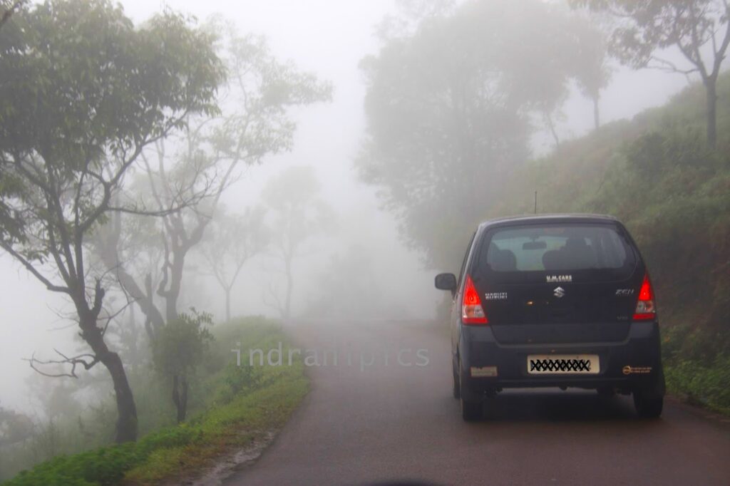
The mist is what defines driving to Mullayanagiri Peak by car. As elevation increases, white clouds engulf the road completely. Locals call these “zero visibility zones,” and the name fits perfectly. During the climb, there are stretches where one can’t see beyond car’s hood. Headlights became useless beyond 3-4 meters, turning every curve into an act of faith.
These conditions require specific techniques. He dropped speed below 20 km/h and switched on hazard lights to alert vehicles behind me. Overtaking becomes impossible and dangerous—the narrow road with steep drops on one side leaves no margin for error. In several sections, he followed the white road edge markings like a lifeline, trusting they would guide through the blind turns.

The mist behaves unpredictably. Dense fog blankets forested bends where sunlight can’t penetrate. Then suddenly, near open ridges, it clears for 30-40 seconds, revealing stunning valley views and terraced coffee estates hundreds of meters below. Just as quickly, the clouds close in again. Understanding this pattern helped me anticipate when visibility would improve.
For first-time mountain drivers, this feels overwhelming. But the fundamentals work: both hands on the steering wheel, moderate speed, and focus on road markings rather than distant landmarks.
Photography opportunities abound in these surreal conditions—cars emerging from cloud banks create dramatic images. I stopped only at designated pull-over points marked by wider road sections. Stopping mid-road, even briefly, blocks traffic on the already narrow route.
The mist-covered drive isn’t just transportation to the summit. It’s Mullayanagiri Peak by car at its most authentic—a test of driving discipline that rewards careful navigation with an experience you’ll remember long after descending.
Refreshments on way up the peak
The Narrow Stretch: Handling the Final 2 Km
The last 2 km before reaching Mullayanagiri Peak present the drive’s toughest challenge. Locals call this section the “Blade Walk” because the road narrows to barely one-and-a-half car widths. On your left, a rocky mountainside rises vertically. On your right, the land drops away steeply into forested valleys below. There’s no shoulder, no barrier, no room for mistakes. (Let me know in comments if there is change.)
Right-of-way rules become critical here. Vehicles climbing uphill get priority—always. When we encountered a descending Mahindra Thar, Arunabha had to reverse 15 meters to reach a slightly wider pocket where both vehicles could squeeze past. My side mirror came within inches of the rock wall. The driver signaled with headlights, Arunabha acknowledged, and we completed the maneuver without drama. This cooperation keeps traffic moving safely.
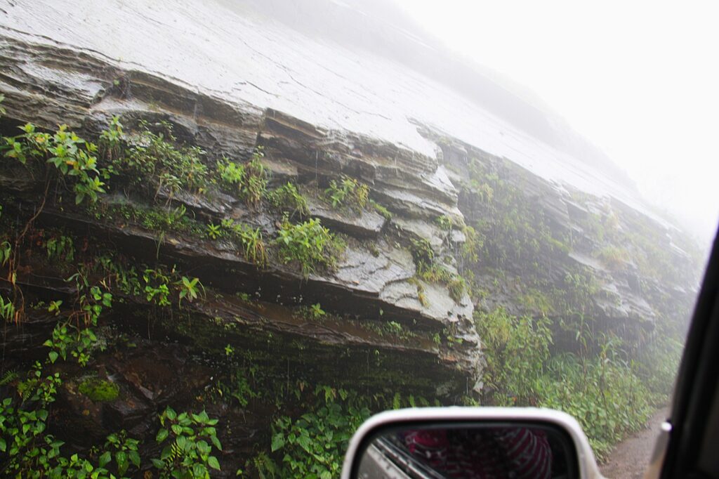
Rocky mountainside
Communication replaces speed. Before entering blind curves, he honked twice—a standard mountain driving practice that warns oncoming drivers. Hand signals through windows work when vehicles approach each other. A raised palm means “wait,” a wave-through means “proceed.” These simple gestures prevent confusion on roads too narrow for mistakes.
Vehicle positioning requires judgment. You must constantly assess: Can my car fit through this gap without scraping the wall or drifting toward the edge? For gear cars, keep in second gear throughout this stretch, using engine braking instead of constant brake pressure. This helps maintain control without overheating the brakes.
The psychological challenge matches the technical one. Seeing the drop on your right while navigating a hairpin tests your nerve.
Pro tip: Focus on the road directly ahead—not the valley below—which will keep steering steady.
Conquering the “Blade Walk” to Mullayanagiri Peak by car isn’t about driving fast. It’s about precision, courtesy toward other drivers, and confidence earned through careful navigation. Once you reach the summit parking area, this final stretch becomes your proudest driving story.
Conquering Mullayanagiri Peak
Parking and the Final Climb (400 Steps)
Once you reach the summit road, vehicles must be parked at the designated lot just below Mullayanagiri Peak. The parking area is basic but sufficient, with space for cars, jeeps, and bikes. Fees are modest—usually collected by local attendants—and it’s advisable to carry small cash since digital payments can be unreliable here.
You can trek all 4 km up the hill or drive up half the way and take stairs till the peak. I chose to do the second option. We availed the jeep service after driving up some distance. (It is advisable to master hill driving skills before you embark on this narrow winding road.)
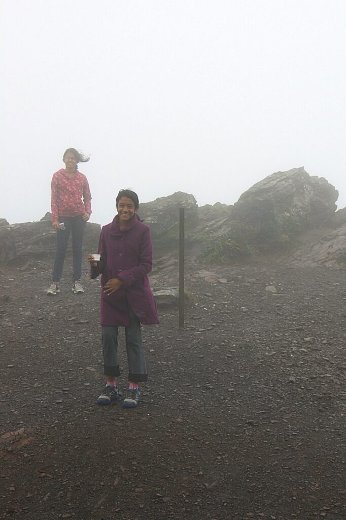
From the parking lot, the journey continues on foot. The climb involves roughly 400 stone steps leading to the Shiva Temple at the peak. The steps are uneven in places, but manageable if you take them slowly. Carry water and wear sturdy shoes, which makes the ascent easier. The mist often lingers even on the staircase, adding to the atmosphere but reducing visibility.

Picture of Chandra Dhrona Hill Range of Western Ghats
Hiking the Mullayanagiri Peak
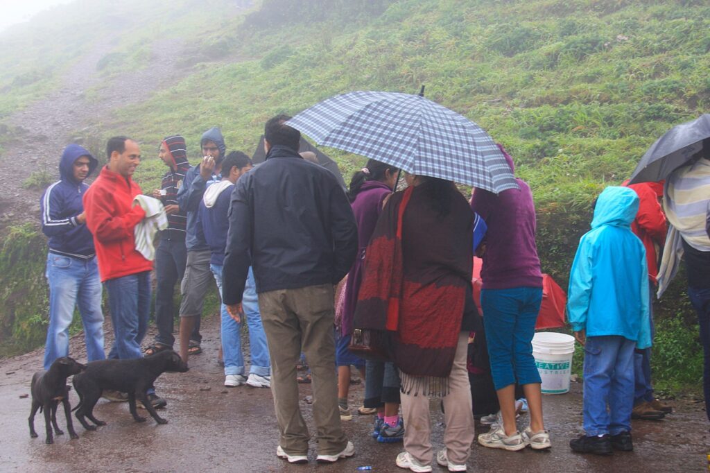
Mullayanagiri Peak is the highest one in Karnataka. It belongs to the chain of hills in Chandra Dhrona Hill Range of Western Ghats of district Chikkamagaluru. I expected no tourists around at the summit; I mean who travels in such a weather! But I was surprised to see good crowd there warming themselves with a cup of tea and munching on choice snacks. The little shops there were making good sales.
There are several local groups which offer to conduct the trek to the summit of Mullayanagiri. Young crowd from IT companies of Bangalore often head to this destination for weekends. And that day was no different. I have several of my pictures dotted with their heads!
Bangalore to Mullayanagiri Peak
Bangalore to Mullayanagiri Peak distance – 265 km. Best option would be to halt at Chikkamagalur and start early to hike up the peak. If you can reach before sunrise you can feast your eyes on some glorious views of the sun rising there. Chikkamagalur to Mullayanagiri Peak distance – 22 km and takes approximately an hour. But on that misty day it took double the time.
Alternative Ways to Reach Mullayanagiri Peak
While driving your own car offers the most freedom, the steep incline and narrow “S-bends” aren’t for everyone. If you’re traveling in a large group or prefer to let someone else handle the hairpins, here are the other ways to reach the peak.
The Local Experience: Hiring a 4×4 Jeep
For many, this is the preferred way to experience Mullayanagiri. Local drivers are experts at navigating the mist and the narrow “Blade Walk” stretch.
- Pickup Points: You can find Jeeps at the Chikkamagalur town center or at the Kaimara Checkpost (the base of the hills).
- Estimated Cost: ₹2,500 – ₹3,500 for a round trip (including Bababudangiri).
- Best For: Large families (6-8 people) or drivers who feel nervous about steep gradients and clutch control.
The Adventurer’s Path: Trekking via Sarpadhari
To truly earn the view, you can hike the Sarpadhari Trail. “Sarpadhari” means “Path of the Snake,” and the trail lives up to its name with its winding, steep ascent.
Starting Point is a small opening on the main road about 5km before the peak. It can take 2 to 3 hours depending on fitness. You get to see the mist rolling over the Shola grasslands from angles that are invisible from the road.
Two-Wheeled Ascent: Bikes and Scooters
Biking to Mullayanagiri is a rite of passage for many in Karnataka.
- Pro Tip: While geared bikes (Royal Enfields, Himalayans) handle the climb easily, avoid taking low-powered scooters (like an Activa) with two heavy adults. The engine can overheat on the final 2km stretch.
- Safety Warning: In the mist, bikers are the least visible to cars. Always keep your headlights on high beam and stay to the extreme left.
Public Transport (KSRTC)
There is no direct KSRTC bus that goes all the way to the Mullayanagiri peak.
How to do it: Take a bus from Chikmagalur heading towards Attigundi or Bababudangiri. You will have to get down at the Mullayanagiri Cross and then either trek up (several kilometers) or hitch a ride with a passing Jeep. This is the least recommended method for families.
Pin and Save this for Later
About the Author
 Indrani Ghose is a cultural travel writer and heritage documentation specialist with over 15 years of experience exploring and writing about temples across India and Southeast Asia. Her work has been published in Lonely Planet, The National (UAE), Whetstone Asia, Deccan Herald, and various architecture and heritage journals.
Indrani believes that travel writing serves as a bridge — helping readers experience places more deeply by providing context, answering questions, and sharing both practical logistics and emotional resonance.
Connect with Indrani: Follow Indrani on Instagram | Twitter | Facebook for heritage travel insights, photography tips, and offbeat destination discoveries.


this is beautiful. refreshed some old memories of the same place we had last year
I have been to Mullayangiri peak during the same kind of weather. Dangerous but adventurous at the time. 🙂 Very beautiful.
That looks like one adventurous drive. There's a lot of mystery to these captures…
The mist actually beautifies the whole picture here!
it is a great place and driving in those curves is fun… Been there twice
Misty roads look inviting. Wish you had written more about Mullayangiri.
This could have been from Bergen in Norway where I live. We are known for all the rain 🙂
I like these misty shots, Indrani. I like the way the photo fades into the background.
The misty fog is pretty but dangerous to drive in! Lovely images. Have a happy day!
The fog is a wonderful filter.
What a beautifully winding road. Gray clouds and mist right out there for you to touch! Must be a difficult drive though!
We have to drive on roads like this fairly often during bad weather. But at least you got some neat pictures. I'm glad you had a safe trip.
Ha ha ha, you never can trust in Google!!!!!!
Lovely Misty Captures..I really enjoy this type of weather…
The mist makes for a nice photo but I know from experience that Indian roads are challenge enough even in sunny weather….
Awesome captures on the mist weather… love the ambiance spread over there.
such a soothing atmosphere always delight to travel
Looks like November in Belgium !
Driving along winding, twisting roads while it is raining is always nerve-wracking to me. But the rain and mist made for wonderfully atmospheric photos.
Zero visibility and you drove on! Great! I love pictures with mist.
A trek to this place is long time pending. May be this October we should conquer this peak.
The mist makes it look mystical, eerie but beautiful at the same time. Nice pics.
It's beautiful… We're starved for misty days here in pune. Looks lovely and smells wonderful too, isn't it
The mist and all looks great but makes driving dangerous specially on hilly areas.
Regards
The misty shots are nice but I'm sorry you didn't get any blue skies.
i love long road trips in this condition. very relaxing and romantic.
Ah, gray, foggy skies!! Looks like here in the northwest US once Autumn arrives! You have captured the fog so beautifully, Incrani! Wonderful shots for the day! Hope you have a lovely weekend!
dangerous for driving, but so beautiful!