Dholavira Harappan Site Gujarat: A Complete Travel Guide
Seven thousand years back, near Kutch on a small isle, the Harappans lived in Dholavira
with remarkable flourish and style. They mysteriously disappeared from the map
of this world till a chance discovery by a local exposed this beautiful settlement.
Its impressive walls, reservoirs, and long-hidden secrets, all intact.
QUICK FACTS of DHOLAVIRA HARAPPAN SITE
Location: Khadir Bet, Rann of Kutch, Gujarat
Best Time to Visit: October to March
Entry Fee: ₹5
Nearest City: Bhuj (130 km)
How to Reach: Road from Ahmedabad or Bhuj
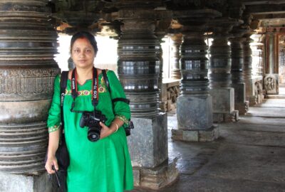
When Dholavira Harappan site got its UNESCO tag on July 2021 I got the opportunity to walk those newly discovered paths of Indus Valley Civilization (all thanks to Gujarat Tourism board). There’s so much to see here—from the excavated site itself to the well-curated Dholavira Archaeological Museum that brings its history alive. In this Dholavira tourism guide, I’ll take you through the must-see attractions, share tips on how to visit, and suggest the best places to stay—so you can experience this incredible slice of Kutch Heritage Tourism just as I did.

Ruins in Dholavira Harappan Site in Gujarat
With this prologue I present to you the highlights about my walk through the prehistoric Indus Valley Civilization ruins (IVC) in Kutch Gujarat. Dholavira archaeological site is the larger of the two Harappan-era city in India, the other one is the Mohenjo-Daro Pakistan.
What is Dholavira?
It is where Harappans lived 7000 years back with remarkable city planning, water management systems, and unique architectural features.
The name sounds strange, doesn’t it! It is interesting how the site got its name – DHOLAVIRA has taken its name from a village 1 km south of Khadirbet in Bhachau Taluka of Kachchh District, in the state of Gujarat in western India. The site is also known locally as Kotada Timba.
Dholavira is Famous. But Why?
Well, Dholavira Harappan site shot to fame recently due to the prestigious tag of UNESCO Heritage site conferred to it on July 2021. This designation recognizes its outstanding universal value as a unique example of a Harappan-era fortified city.
Dholavira ranks fifth in terms of size. It was once a major hub within the Indus Valley Civilization (IVC), renowned for its architecture, civic infrastructure, and insights into Harappan life.
The four preceding IVC sites are:
- Rakhigarhi (Haryana, India)
- Mohenjo-Daro (Sindh, Pakistan)
- Harappa (Punjab, Pakistan)
- Ganeriwala (Cholistan Desert, Pakistan)
History of Dholavira Harappan Site
Discovery of Dholavira Site
Harappan ruins existed at this site since 3000BCE (Before Common Era). This particular hillock was hardly inhabited and few patches here and there were used for farming and grazing for animals. It was during one of those tilling of grounds here that threw up pottery remains and the like. Archaeologist Jagat Pati Joshi was working in nearby site Ropar. He was informed of these findings by the farmers. After inspection and radiocarbon dating on the findings, he confirmed they belonged to Harappan times.
Thus Jagat Pati Joshi archaeologist is credited as the one who discovered the Dholavira site in 1968.
The nearest village to this was the village Dholavira and thus the site took over the name Dholavira Harappan Site.
It took some more years for the excitement to build up around this discovery and some more tests and carbon dating on the finds after which serious excavations started here.
Indus Valley Civilization
This guide to Dholavira tourism will be incomplete without the mention of Indus Valley Civilization and how they are connected.
Isn’t it exciting to think that long long back, almost 7000 years ago (3300 BCE – 1300 BCE), a civilization existed that boasts of city planning, efficient drainage systems, far-reaching trade network, artistic and technological expertise?! Indus Valley Civilization was all of these.
As per carbon-dating of fossils obtained from the sites, Indus Valley Civilization is ranked among the earliest civilizations in human history.
The Indus Valley Civilization covered an area of approximately 1.25 million sq.km., including much of modern-day Pakistan, north-western India and northeast Afghanistan. It is hard to nail the figure as more and more sites are being unearthed. However, the Indus Valley Civilization is counted as one of the largest ancient civilizations, comparable in size to the contemporary civilizations of Egypt and Mesopotamia.
Dholavira Indus Valley Civilization Map

Dholavira Harappan Site – Map and Signboard
All about Dholavira Harappan site
Let us now get the facts and figures about Dholavira Archaeological site.
The size and shape of Dholavira site
It is one of the nine Harappan sites in India. Dholavira is ranked as most prominent, second largest Harappan archaeological site in India and fifth largest in world belonging to the Indus Valley Civilization. This ancient city is HUGE measuring 120 acres and is shaped like a quadrangular city.
Here’s a list of Harappan sites in India based on size, from the largest to smaller notable sites:
- Rakhigarhi (Haryana) – Approximately 350 hectares
- Dholavira (Gujarat) – Approximately 120 hectares
- Lothal (Gujarat) – Approximately 7 hectares
- Kalibangan (Rajasthan) – Very small, measures- 130m on the east–west axis and 260m on the north–south.
- Banawali (Haryana)
- Surkotada (Gujarat)
- Ropar (Rupnagar, Punjab)
- Bhirrana (Haryana) – Smaller than the sites above
- Alamgirpur (Uttar Pradesh) – Again, smaller than the ones above
These rankings provide a sense of the scale and importance of the Harappan sites in India, with Rakhigarhi and Dholavira being the most expansive and historically crucial within the subcontinent.
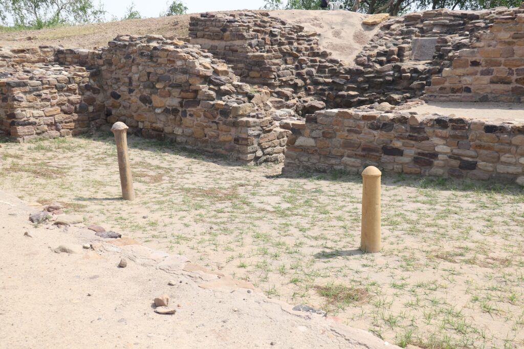
Smooth pillars found in Ceremonial ground, their purpose not deciphered yet
Where is Dholavira located?
This, once prosperous Harappan site lay between two seasonal streams, the Mansar in the north and Manhar in the south. Dholavira is located on Khadir Bet Island in the Kutch Desert Wildlife Sanctuary in the Great Rann of Kutch, Gujarat. Another significant landmark is Dholavira archaeological site lies on the Tropic of Cancer.
Curious about what was found in Dholavira?
Like me, you too will be amazed to know what was found in Dholavira site.
Systematic excavations started here in 1990 and went on till 2004. Remains of a big factory of making pearls has been found in this town that has stunned historians all over. Copper distilleries, well-planned water management system, water tunnels (through which water once flowed, but now dry and empty), fortified citadels with brick homes, state-of art granaries and more were excavated from the archaeological remains here. The excavation work is still on in some parts of the site and the world is waiting what more treasures will be found in Dholavira.
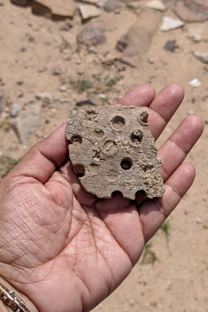
Perforated potsherd found in Dholavira site
Among the fossils found in Dholavira are the gems and coins, broken worn out artefacts like terracotta pottery, beads, gold ornaments, seals, fish hooks, animal figurines, copper tools and urns all now kept in the Dholavira Archaeological Museum. During my walk there, I too spotted broken bits of perforated jars, terracotta pots and parts of skeletons.
Several vessels and artefacts collected here indicate a different style hinting at trade connections with countries and civilizations far away like that of Mesopotamia.
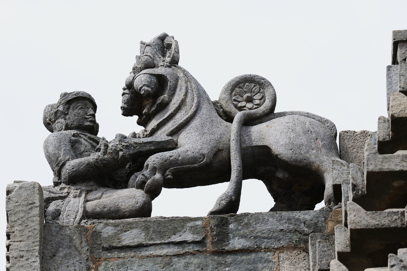
10 large stone inscriptions, probably some letters of Harappan script were found near the Ceremonial Ground. They are not deciphered yet, but are assumed to be some kind of signboard.
During excavations no human remains have been found at Dholavira in Kutch. This is not the case when compared to other Harappan towns in Gujarat, such as Lothal.
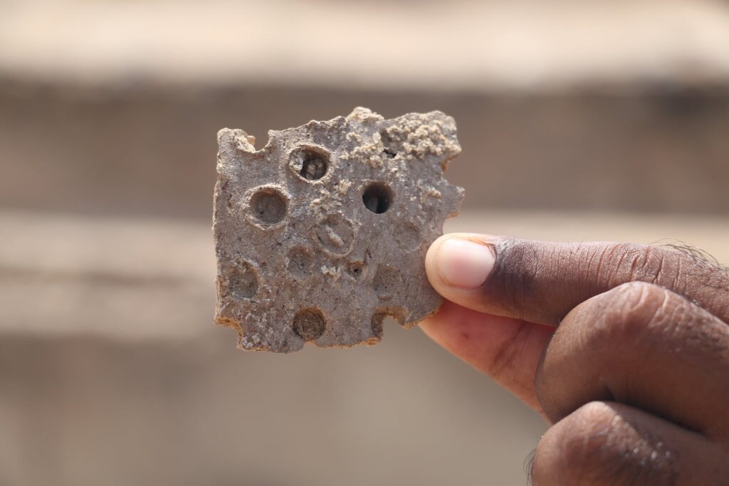
Part of perforated jar found during our walk in Dholavira Harappan site
Dholavira Symbols – A 10 lettered signboard was found in the western chamber of North Gate of Castle, (c. 2500-1900 BC). It is not deciphered yet what the symbols exactly meant. The “wheel-form” symbol appears four times in the signboard. Could it be similar to the alphabet ‘E’, the most commonly used alphabet in English?
Parts of Dholavira Site:
Know the parts of the site, this will help you to plan the tour of the site well. Our guide right at start of the tour drew the broad outline of the Dholavira Harappan site on ground with a stick. Once more, though so late in life, I felt I was in a classroom. The town of Dholavira is divided into three parts:
- Raj Mahal, The Citadel of the Raja/Ruler situated on an elevated platform. It was surrounded by strong fortifications all around. There were four gates in this fort. This is the highest and most fortified part of Dholavira. It is believed the citadel served as the administrative and the ceremonial centre of the city. Take time to notice and capture the robust walls made of stone, wide streets, and large structures; proofs enough to indicate it was home to the ruling elite or administration.
- The Middle Town – Located adjacent to the citadel, the middle town functioned as a buffer zone between the citadel and the lower town. The fortifications and residential and administrative structures indicate it was likely occupied by officials, merchants, and skilled artisans. These habitats of other officers had two to five rooms, and also had a protective wall.
- The Lower Town – The largest part of the city clearly meant it for the general populace. The residential blocks were smaller but had systematic layouts, narrower streets, and public spaces. If you fail to notice on your own the provisions for drainage, water management, and public amenities take the guide’s help.

Map of Dholavira Harappan site
Timeline of Dholavira History
Dholavira has long span of being inhabited by humans. It is categorized in to seven stages from the rise to maturity and finally the fall of the civilization.
- Stages I to III belong to early Harappan (3000 – 2600 BCE).
- Stages IV and V stretched from 2600 to 1900 BCE. Stage VI is the late Harappan period from 1900 to 1600 BCE.
- Stage VII belongs to post urban Harappan from 1600 to 1500 BCE. After which the place was completely abandoned. It is believed a long 150 years of drought period completely finished the human race here.
- In Dholavira, the city shrunk to one third its original size in the sixth stage and habitation was restricted to Middle Town.
- By seventh stage the populated area shrunk to Castle and Bailey. People lived in circular houses which are similar to traditional Bhunga houses of Kutch region that can be seen today.
Evidences of Trade
Mesopotamian trade records in the form of cuneiform tablets from the Akkadian Empire (2334–2154 BCE) and the Ur III period (2112–2004 BCE), contain references to Meluhha (Harappans) as a significant trading partner. These texts describe goods such as carnelian, lapis lazuli, ivory, gold, and exotic woods that were imported from Meluhha, which matches the resources known to have been traded by the Indus Valley Civilization.
Another piece of possible evidence that points to the people of Meluhha as being Proto-Dravidian is the fact that sesame oil believed to be exported to Mesopotamia by the Harappans, was known as ilu in Sumerian and eḷḷu in Akkadian. from: https://en.wikipedia.org/wiki/Meluhha
Archaeological finds from sites like Dholavira, Lothal, and Mohenjo-Daro show the presence of Mesopotamian artifacts such as seals, beads, and pottery styles, supporting the notion of extensive trade networks. Such strong interdependency could be one of the factors that led to decline of both civilizations almost around the same time.

Circular houses in Dholavira Harappan Site Gujarat
Highlights of Dholavira Harappan Site
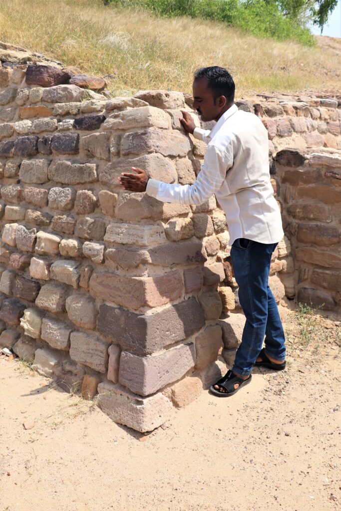
Stone Architecture of Dholavira – Smooth finish to Structures
Walk through the site shows an imposing citadel in the centre, with a middle and lower town. Mind you there are no standing structures only plans and foundations remain. It is amazing to note that the structures recovered were made with pleasingly smooth structures of stone masonry.
Most Harappan sites discovered have structures made of stone chiselled to brick shape as there was lack of water and abundance of stones. I actually ran my palm across the smooth surface of the displayed stone there, to feel it, as if only seeing wasn’t convincing enough.

Bi-concave Pillars
Sophisticated Harappan Urban Planning
As the guide explained further I was amazed at the incredible town planning that existed in those days. Well laid out lanes crisscrossed the parts of the town systematically from the citadel. The houses were made round shaped to prevent damage from earthquakes. And this was only the topmost layer. Underneath our feet lay four more layers.
Harappan civilization progressed from to maturity to decline. Evidences of these stages are found in the different layers they excavated. Many parts that were dug up for studies have been refilled and left underneath. This is to protect them from further damage and erosion, also due to lack of funds for maintenance and upkeep of the sites.
Water Conservation in Ancient India – Planned Drainage System
A well-constructed underground drainage system for sanitation is a mute proof of the engineering skill that existed then. It has dimensions of height six feet, high enough for a tall man to walk through easily. Till date Dholavira holds the record of having the world’s earliest water conservation systems ever excavated.
Our guide who is a native of this site said that, “In our childhood days I used to walk through these tunnels with my friends without realizing the significance of it.”
Exciting isn’t it? Don’t try it now though… it is prohibited.

Water tunnel in Dholavira UNESCO World Heritage Site

The tunnel ended here
The Citadel: An Ancient Seat of Power
Castle and Bailey together formed the citadel; our walking tour was mainly through this area, Upper Town, the water channels, reservoirs and North Gate. Beyond the citadel lay the Middle Town and then the Lower Town which has several residential blocks, then the wall and finally the cemetery. The whole site is rectangular in shape and covers an area of 54 acres.
Ceremonial Ground
An area in Middle Town identified as stadium. Partially excavated arena with seating arrangement, a huge stadium with a complex structure is testimony to the fact that sports and games were conducted on a large scale. Parts of it are still not excavated. The empty space was probably used for festive occasions, ceremonial functions or as a market place.

This the edge of Citadel. You can see the ceremonial ground and parts of amphitheater (bricks at a distance) in this Ancient city of Dholavira
Dholavira’s Advanced Water Conservation System
Check Dams
Many of the ancient civilizations flourished on river banks. In Dholavira there were just two streams which was the main source of water. There are evidences of several check dams across the nullahs (streams) Manhar and Mansar to divert water into the reservoirs.
East Reservoir
There are 16 reservoirs in the site, among them the east reservoir is the largest, grandest and best furnished reservoir. At three corners there are a flight of 30 steps. Excavators found a rock-cut well with steps and stone made enclosure inside the reservoir. They also found evidences of performance of rituals, broken figurines, complete unicorn figurine and thus concluded the reservoir to be of high importance.
Their well developed reservoirs, drainage systems, small baths are a proof of how they conserved water. Without these the settlement would not have thrived in the sparse rainfall of the desert.

East Reservoir in Dholavira Harappan Site Gujarat
The World’s Oldest Unread Signboard
One of the most fascinating finds at Dholavira is a huge “signboard” discovered just outside the north entrance to the citadel. It carries one of the longest known Indus inscriptions—10 large symbols, each about 37 cm tall, arranged on a board nearly 3 meters long. Interestingly, one symbol is repeated four times.
The letters were crafted from white gypsum, like mosaic tiles, and fixed onto a wooden frame. Over time, the wood rotted away, but the symbols stayed in place on the ground, giving us a glimpse of this unique artifact.
Archaeologist R.S. Bisht believes this sign dates back to Stage IV of the classical Harappan culture. Since it was found near the gateway, it’s thought to have served as a signboard that greeted visitors entering the city. What it actually said, however, is still a mystery—because the Indus script remains undeciphered to this day.
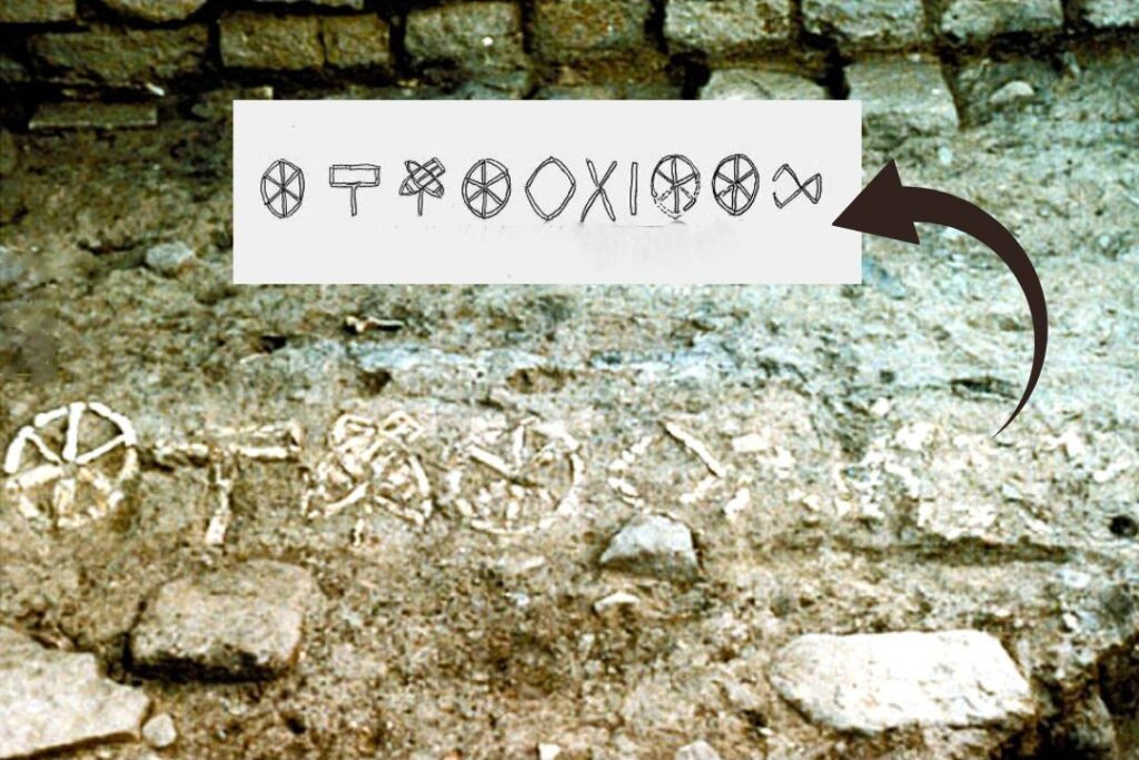
The Unique Ten Indus Signs Board – An Ancient Message… We Still Can’t Read
Decline of Dholavira
Having heard this long story of prosperity of Harappan civilization in Dholavira we were naturally curious to know the how and why of the decline of Dholavira. The guide explained to us several possible reasons why the humans would have abandoned this once flourishing city. Further reading up threw some light on this mystery:
One of the leading theories is that a significant shift in monsoon patterns in Dholavira led to a long 150 years of drought period that completely finished the human race here. A decline in rainfall would have severely impacted agriculture. The water resources, the Dholavira rivers Mansar in the North and Manhar in the south, which were fed by rainwater and seasonal in nature must have dried up.
Geological and sediment studies around Dholavira indicate that the region experienced a shift toward a drier climate during the late stages of the civilization.
Geographically Dholavira is estimated to lie along a fault line hence destroyed by earthquake. There is evidence suggesting that tectonic activity might have caused changes in the course of rivers or contributed to earthquakes.
Some researchers argue that the gradual drying up or shifting of rivers like the Saraswati (Ghaggar-Hakra) could have contributed to decline of the Dholavira Harappan civilization.
The change of the course of Saraswati River altered the geography of the place. The people from here are believed to have migrated to the fertile plains of Ganga – thus avoiding the arid condition of Kutch.
There is no evidence that wars or conflict contributed to the decline of the Indus Valley Civilization. This underscores that the Harappan clan was truly ‘civilized’ in every sense of the word.
On a lighter note I am reminded of a true incident when a sixth grader was asked in history exam ‘why did Harappan civilization end?’
The class 6 girl replied: The people of Harappa decided to go on a vacation. They went to new lands and found the place more interesting hence they settled there and never returned to Harappa.
Tilt in walls as protection against Tsunami
Location of Dholavira Harappan Site in Gujarat
Dholavira village sprawls over 100 hectares of semi-arid land at the north-west corner of Khadir Island of Gujarat the westernmost state of India. This island of Great Rann of Kachchh is at a higher elevation than the rest of the desert. So when rest of lower lying area is submerged by the monsoon rains this place is relatively dry. The land here was used for grazing farm animals and farming on a very low scale. It is close to Tropic of Cancer.
Geographical Coordinates: 23.88° N, 70.21° E
Distance Chart for road trip to Dholavira
If you are doing a Gujarat tour and plan to visit Dholavira know this distance chart:
- closest tourist destination to Dholavira Harappan site is Dhordo, a distance of 88 km
- Bhuj to Dholavira road trip – the distance is 130 km
- Ahmedabad to Dholavira road trip, distance is around 340 km
- Rajkot to Dholavira is at a distance of 259 km by road
- Jamnagar is at a distance of 288 km by road
- the distance between Dwarka to Dholavira is 433 km by road (take a train or make halts at Jamnagar, Dhordo and Bhuj).
How to Reach Dholavira
The easiest and only way to reach Dholavira is by road. Dholavira is close to Bhuj Airport (216 km) and Ahmadabad (358 km). Bhuj is the closest railway station to Dholavira. There are public transport services at fixed intervals. Alternately you can hire private taxis from both these cities.
We took private taxi from Ahmadabad, travel time is seven hours but we made several halts. The road to Kutch from Ahmadabad is dotted with UNESCO site Rani Ki Vav, Patan silks sari weaving unit, Modhera Sun Temple, Indian Wild Ass Sanctuary and the most amazing Salt lake on the way to Khadimbet Island the final destination.
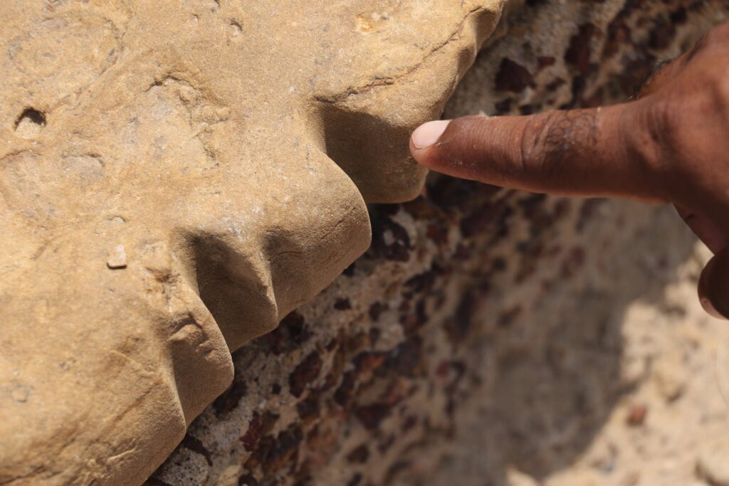
Grooves on stones near wells that indicates ropes were used for pulling up water containers
Best Time to Visit Dholavira
Dholavira in Kutch lies on the Tropic of Cancer has extreme climatic conditions. Avoid visiting in summers at any cost. The best months to visit the Indus Valley Civilization site in Dholavira is from October to March when temperature ranges from 19 degrees minimum to a bearable 36 degrees maximum.
Do give a read: Things to Do in Dholavira when you plan a visit to the UNESCO site.
Places to visit in Kutch
- Do include Dholavira Archaeological Museum which has a lot of information along with neatly arranged samples of finds.
- Dholavira Fossil Park nearby has good collection of tree fossils.
- Chipper Point Dholavira in Kutch gives amazing views of salt lake all around. It is a good sunrise and sunset point. Do exercise caution as it is precariously located on a naturally made ledge.
Dholavira entry fee and timings
Tickets cost 5INR per tourist.
The site is open from 9 AM to 6 PM.
With guide – when we paused to rest
Smart Travel Tips to Visit Dholavira Archaeological Site
- Take plenty of water if you intend to tour three hours in a stretch there.
- Use sunscreen and umbrella or hat.
- Study up the place a bit or better still save this post that will help you understand the site better.
- Hire a local guide. There are some who actually worked during the excavation there.
- There are information boards near each excavated point, pause to read them up for better understanding.
- Photography is allowed, but respect signboards and restrictions.
- Stay at nearby guesthouses or eco-resorts if you want an early start.
What Not to Do at Dholavira
- Don’t litter – help preserve the site’s natural and historical environment.
- Don’t climb on the ruins or touch fragile structures.
- Don’t remove stones, pottery, or any artifacts – it’s strictly prohibited.
- Don’t ignore signboards or restricted zones within the excavation area.
- Don’t disturb the silence of the place – it’s an archaeological site, not a picnic spot.
- Don’t rely on mobile networks; connectivity is weak – plan accordingly
Dholavira: Frequently Asked Questions (FAQ)
How old is Dholavira?
Archaeological evidence suggests that Dholavira dates back around 7,000 years and was continuously occupied for over 1,500 years.
Is Dholavira worth visiting?
For sure, a must visit! For anyone interested in history, archaeology, or ancient civilizations, Dholavira offers a rare chance to walk through a 7,000-year-old Harappan city, a glimpse into one of humanity’s earliest urban centers..
What makes Dholavira different from other Harappan sites?
Unlike many other Indus Valley sites, Dholavira is well-preserved and showcases a sophisticated water conservation system. The structures are made from smoothed structures of sun-dried brick and stone masonry.
Which river flows in Dholavira?
Luni River. Dholavira is on the banks of the river Luni, in Kachchh District of Gujarat state in India.
How much time is needed to explore Dholavira Harappan site?
To explore the site thoroughly, including the main archaeological park and the adjacent museum, you should plan for at least 3 to 4 hours. This allows you to walk through the different parts of the ancient city without rushing.
Are there any hotels or places to stay near Dholavira?
Accommodation options are limited right near the site. The Toran Resort (Dholavira Tourism Resort), managed by Gujarat Tourism, is the primary option. Several smaller guesthouses and homestays are also available in the nearby Dholavira village. For more options, travelers often stay in Bhuj or Rapar.
How was Dholavira destroyed?
National Institute of Oceanography Director SWA Naqvi said, “The archaeological site of Dholavira in the Rann of Kutch in Gujarat was destroyed by a tsunami around 3,450 years ago.” Other associated reasons are: Climate change, likely triggered by tectonic activity and shifting monsoon patterns that led to prolonged droughts.
Pin this for later
Save and share this post with your friends and to plan an adventure for later.

 Indrani Ghose is an Indian Travel Writer and Blogger based in Bangalore, India. She has written for numerous publications across the globe – including Lonely Planet, The National UAE, Whetstone Asia, Deccan Herald. You can follow her on her social media handles Instagram, Twitter, Pinterest and Facebook to see the wonderful destinations, beautiful offbeat places and get instant updates about them.
You will find these Gujarat travel blog posts interesting:


India certainly has some amazing places full of interesting history and Dholavira Harappan Site is definitely no different. So cool that you got invited on a blogger’s press trip to write about Dholavira Archaeological Site of Indus Valley Civilization. Their engineering sounds like it was well ahead of their times with the well-constructed underground drainage system for sanitation. Sounds like another place I need to add to my list.
Such an incredible history. The water conservation system in Dholavira is a great show of the engineering marvels from the past. Imagine running through the tunnels as a kid only to find out later the historic significance they had haha
I love the chiselled stone bricks, they’re gorgeous. It’s so interesting to read about the sanitation and drainage systems. It’s quite mind-blowing to imagine how they lived out there all those years ago. I think I’d be keen to hire a guide to get all of the best information.
How great to get invited to be part of a team to visit the Dholavira Harappan Site. Such an interesting history for the site. I am sure the guide added much insight into the site layout and construction processes. I too am always amazed at how advanced they were. We would definitely add a stop at the museum.
The circular houses remind me of some pueblo remnants in Arizona, USA. The stones at this site are incredible for being so ancient.